There are two ways to reach the south of Colombia from Cartagena. One can take the west road using the Pan-American Highway through Medellin and Cali, or the east road, through Bucaramanga and Tunja. We took the latest, in part because it is less touristy, and also because there were some people we wanted to touch base with in the capital.
After getting the containers guarantee back on Monday morning, we said good-bye to our French friends. They would use the other road, so we were splitting. We may meet them later, around Popayan.
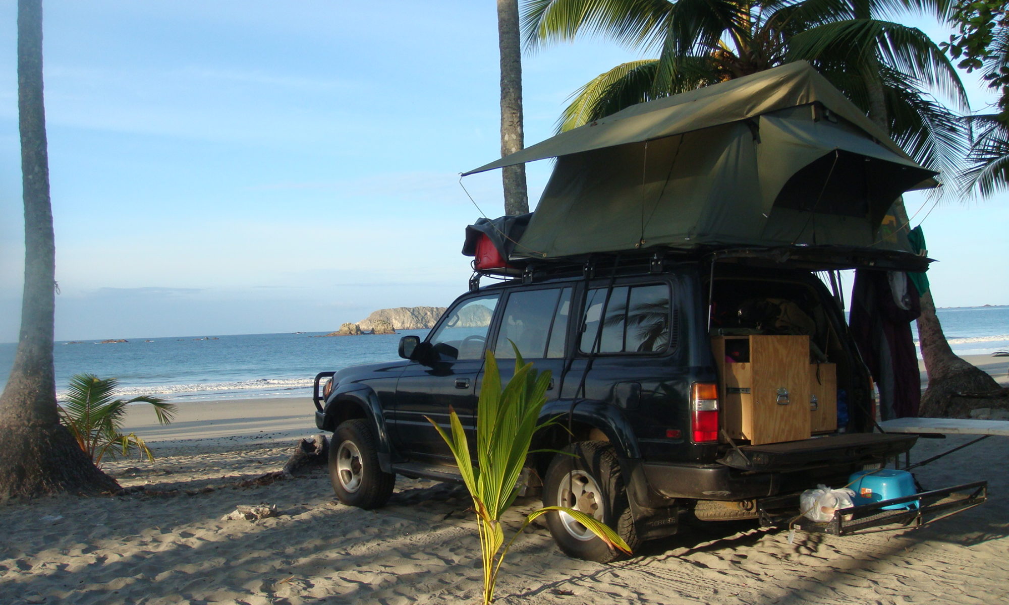
The first day of driving was one of the hottest we got so far. Hot and dry. I hear Colombia is in the middle of a drought, which doesn’t help. I drove 500 kilometers (310 miles), and we stopped to camp in a farm. At night, we played dominoes with the kids. Such hot climate is difficult, because in the morning and evening, you REALLY want to take a shower, which can be hard. When it’s not so hot, we can take a shower every two days, and take care of the rest of our needs with buckets of water. Luckily, on this precise night, we were able to take a shower at the farm.
The following day, shortly after we left, the road began to climb in the mountains toward Bucaramanga. We reached the big city in the afternoon, and took advantage of the populated place to go to a supermarket. It was somewhat difficult to find places to shop, as we crossed mostly small villages on our way.
After Bucaramanga, the road became one of the most beautiful I ever drove. The Canon del Chicamocha in particular is worth seeing before you die. As night felt, we reached the entrance of the national park of the same name. We tried our luck and asked if we could camp inside the park. They let us in after the police gave us the authorization, and we were given an amazing spot few meters from the canon. Probably the most notable place I slept since Guatemala.
If you happen to be around there, go to the park, find the administration building, ask them the authorization to camp, then go to the police building where they will take your plates and passport numbers. Te overall procedure takes ten minutes, and is free.
The morning after, the view was still as splendid, and we continued our way, up to 3,200 meters high (10,500 feet). The most beautiful part was right before reaching Tunja. From there we went west to spend the night in Villa de Leyva, a major touristic destination 150 km from Bogota.
There, we could not get anyone to let us camp, so we went deep in the hills, far from everything and tried to find a spot in the cold and lunar landscape. After picking one, took the table out, opened a beer, and began to set camp in the strange area. We didn’t stay for long. After few minutes, we began to hear a mysterious music and people singing in the night. Let me tell you that we were out of there in no time.
Later, in the center of Villa de Leyva, we found a camping, and were happy to pay US$10 to not be attacked by ghosts from an Indian cemetery.
In the evening and early morning, we spent time walking in the city. The town has been preserved since declared a national monument, in the 1950s. There is no modern building in the whole town of 13,000 inhabitants. Locals are really nice, and strolling across the place on the stone streets. Sights include large 120 meters by 120 meters may be the largest in the country and four churches round the center.
Next step, Bogota where Frank, the chief of the Andean news for the AP got us a spot for few nights.
Climbing the mountain toward Bucaramanga
There are two ways to reach the south of Colombia from Cartagena. One can take the west road using the Pan-American Highway through Medellin and Cali, or the east road, through Bucaramanga and Tunja. We took the latest, in part because it is less touristy, and also because there were some people we wanted to touch base with in the capital.
Along the east – or dry – route
After getting the containers guarantee back on Monday morning, we said good-bye to our French friends. They would use the other road, so we were splitting. We may meet them later, around Popayan.
The first day of driving was one of the hottest we got so far. Hot and dry. I hear Colombia is in the middle of a drought, which doesn’t help. I drove 500 kilometers (310 miles), and we stopped to camp in a farm.
At the farm
At night, we played dominoes with the kids. Such hot climate is difficult, because in the morning and evening, you REALLY want to take a shower, which can be hard. When it’s not so hot, we can take a shower every two days, and take care of the rest of our needs with buckets of water. Luckily, on this precise night, we were able to take a shower at the farm.
Mountain village
The following day, shortly after we left, the road began to climb in the mountains toward Bucaramanga. We reached the big city in the afternoon, and took advantage of the populated place to go to a supermarket. It was somewhat difficult to find places to shop, as we crossed mostly small villages on our way.
The Canon
After Bucaramanga, the road became one of the most beautiful I ever drove. The Canon del Chicamocha in particular is worth seeing before you die. As night felt, we reached the entrance of the national park of the same name.
Mountains as night fall
We tried our luck and asked if we could camp inside the park. They let us in after the police gave us the authorization, and we were given an amazing spot few meters from the canon. Probably the most notable place I slept since Guatemala.
Our campsite, overlooking the canon
If you happen to be around there, go to the park, find the administration building, ask them the authorization to camp, then go to the police building where they will take your plates and passport numbers. Te overall procedure takes ten minutes, and is free.
Breakfast in the early hours
The morning after, the view was still as splendid, and we continued our way, up to 3,200 meters high (10,500 feet). The most beautiful part was right before reaching Tunja.
North of Tunja
From there we went west to spend the night in Villa de Leyva, a major touristic destination 150 km from Bogota.
There, we could not get anyone to let us camp, so we went deep in the hills, far from everything and tried to find a spot in the cold and lunar landscape.
Villa de Leyva main plaza.
After picking one, took the table out, opened a beer, and began to set camp in the strange area. We didn’t stay for long. After few minutes, we began to hear a mysterious music and people singing in the night. Let me tell you that we were out of there in no time.
Iglesia del CarmenStreet of Villa de Leyva.
Later, in the center of Villa de Leyva, we found a camping, and were happy to pay US$10 to not be attacked by ghosts from an Indian cemetery.
In the evening and early morning, we spent time walking in the city. The town has been preserved since declared a national monument, in the 1950s. There is no modern building in the whole town of 13,000 inhabitants. Locals are really nice, and strolling across the place on the stone streets. Sights include large 120 meters by 120 meters may be the largest in the country and four churches round the center.
Street of Villa de Leyva.
Next step, Bogota where Frank, the chief of the Andean news for the AP got us a spot for few nights.
We woke up in the old city on Wednesday morning. The vehicles were not supposed to be here before Friday, which was perfect, given that there was a lot to see around. The first thing we did was to move to a cheaper hotel, located in the center of the city. We settled on the Centenario hotel (not in the guides, but recommended, US$30 a night). The place is located in the old Getsemani district, outside of the walls of El Centro.
El Centro, inside the walls
The climate was pretty hot, with 31 degrees C during daytime (88 deg. F), but a nice breeze was blowing every night, which is the best time to walk around.
Waiting for the boat to unload the containers
It took all day Friday and Saturday to get all the paperwork done, and as usual, the temperature was not making things easier. Finding someone who could unload the containers and then a customs officer in the port can be time consuming.
Street, inside the walls
Employees of the port were nice and helpful, served us coffee, and indulged our presence during these two long days. At the end, the unloading fees amounted to app. US$ 300, which bring the shipping cost around the Darien to US$1,250.
Cartagena, outside the walls
Since we had some guaranty money to get back on Monday, we stayed in Cartagena through the week end, and just walked up and down the cobbled streets of El Centro, where the upper classes lived in the past, and probably still live.
San Pedro Claver Covent
There, we visited the San Pedro Claver Covent. San Pedro, a Jesuit monk also called the ‘Apostle of the Blacks’ spent his life ministering to the slaves brought from Africa. The building was charming, and there are some interesting paintings (portraits) as well.
The Naval Museum
The Naval Museum also merits a visit, with captioned models of pirate attacks from the 16th century. Building equally interesting. The Gold Museum is free, and you should go if you like jewelry. I was more curious about the archeological side, and liked the explanation about agricultural methods used in the country.
Model at the Gold Museum
At the end of the day Saturday, when we got our trucks back, we moved to Boca Grande, another Cartagena district along the beach. There, we paid US$5 a night to camp in a parking lot, across the street from the sea.
The walls of Cartagena
On Sunday night, I met with Frank, whom’s brother Alberto helped in the past with parts and shipping quotes.
Old Cartagena at night... in the daytimeOne of the fort in Cartagena outskirt
Frank spent two hours pointing out roads I should take to reach Bogota. Good guidance helps in Colombia, for safety and also to save money, as toll roads are everywhere, and those are not cheap. Gas is also a bit more expensive than in the U.S., at US$ 3.10 a gallon. In Panama, gas prices were similar to the U.S.
Eventually, on Monday we resumed our travel, and took the Southeast road to Bogota. Colombia is a big country compared to all the small ones we crossed in Central America, and we are probably here for more than a week. It should take us 3 days to get to the capital in the mountains.